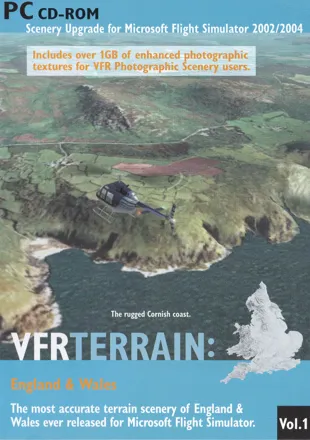
VFR Terrain: England & Wales

Description
Using data from Intermap Technologies' NEXTMap Britain™, VFR Terrain is the most detailed and accurate terrain mesh upgrade ever released for Microsoft Flight Simulator.
VFR Terrain sets a new standard in terrain mesh scenery:
-
The terrain mesh is generated from the most accurate countrywide data available, and is provided at the maximum level of detail that Microsoft Flight Simulator can display (c. 19m in FS2002 and c. 38m in FS2004*).
-
Larger lakes and estuaries have been designated interactive, giving you moving, reflective surfaces and the option to land float aircraft.
-
Special attention has been paid et coastlines, including almost 1 GB worth of replacement photographic textures for VFR Photographic Scenery users.
* A limitation in the code of FS2004 has reduced the maximum terrain mesh to half that of FS2002.
Ɨ All screenshots displayed show VFR Terrain with VFR Photographic Scenery (sold separately), unless otherwise stated.
Includes aerial photography from the Millemium Map™. Includes elevation data from NEXTMap Britain™
Source: Back Cover
Groups +
Analytics
Upgrade to MobyPro to view research rankings!
Related Games

Released 2002 on Windows

Released 2007 on Windows

Released 2007 on Windows
Released 2002 on Windows
Released 2015 on Windows

Released 2002 on Windows
Released 2004 on Windows
Released 2019 on Windows
Released 2019 on Windows
Identifiers +
Contribute
Are you familiar with this game? Help document and preserve this entry in video game history! If your contribution is approved, you will earn points and be credited as a contributor.
Contributors to this Entry
Game added by piltdown_man.
Game added June 26, 2023. Last modified November 27, 2023.